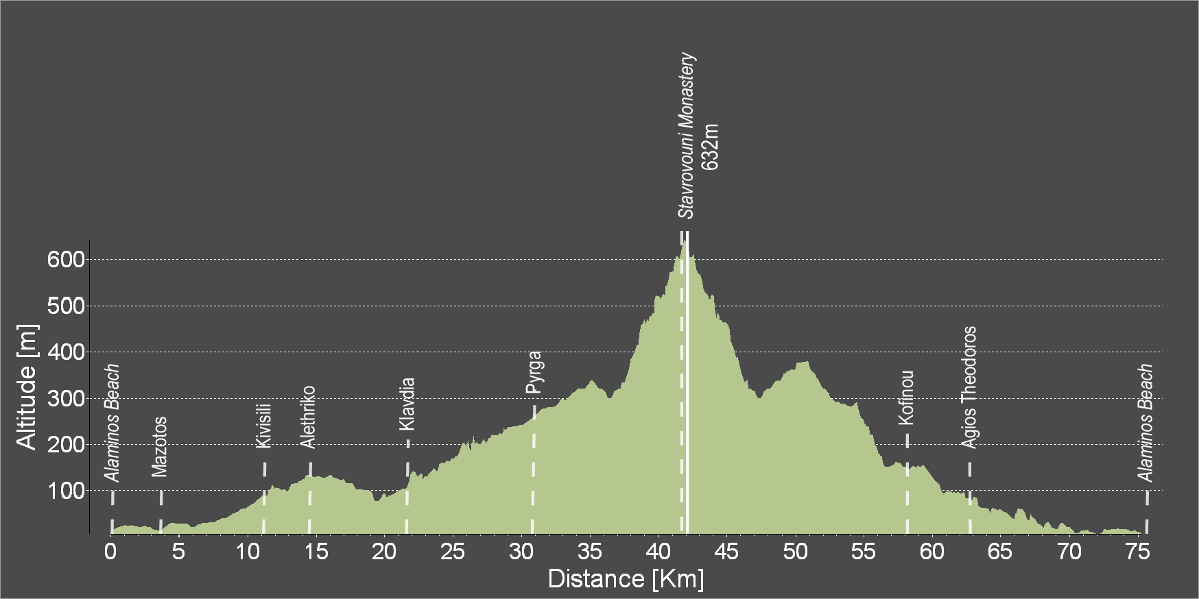
Alaminos Fishing Shelter - Kivisili - Alethriko - Klavdia - Pyrga - Stavrovouni - Kofinou - Agios Theodoros - Alaminos Fishing Shelter
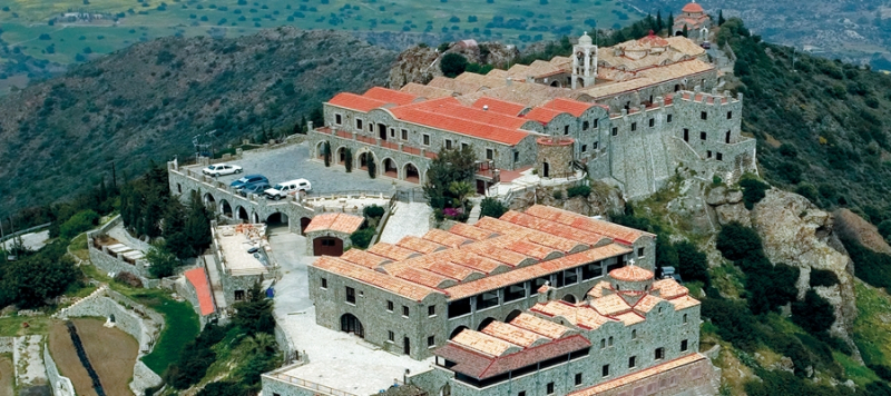
Diese Tour beschreibt nicht nur einen Kreis um Stavrovouni Mountain ("Berg des Kreuzes"), Sitz des gleichnamigen griechisch-orthodoxen Klosters, in dem ein Stück des Heiligen Kreuzes Christi aufbewahrt wird. Nach der Fahrt durch die sanften Hügel des Küstenstreifens und die Wälder um Pyrga und Kornos wartet der Aufstieg. Scheinbar endlos weite Blicke öffnen sich auf dem Weg nach oben - über die Ebene Larnakas (Larnacas), das Meer und das Trodoos-Massiv. Schöpfen Sie Ruhe und Kraft an diesem zeitlosen Ort bevor es zurück zur Küste geht.
Bitte klicken sie hier zum download die beschreibung der route.
Bitte klicken sie hier zum download die route im gpx-format.
| Distance: | 74.9km |
| Elevation Gain: | 878m |
| Highest point: | 632m |
| Lowest point: | 6m |
| Loop: | YES |
| Terrain: | Mixed |
| Road surface: | Paved |
| Section Distance (km) | Total Distance (km) | |
| Alaminos Beach | 0.0 | 0.0 |
| Mazotos | 3.8 | 3.8 |
| Kivisili | 7.1 | 10.9 |
| Alethriko | 2.7 | 13.6 |
| Klavdia | 7.7 | 21.3 |
| Pyrga | 9.9 | 31.2 |
| Stavrovouni Monastery | 10.7 | 41.9 |
| Kofinou | 16.9 | 58.8 |
| Agios Theodoros | 4.3 | 63.1 |
| Alaminos Beach | 11.8 | 74.9 |

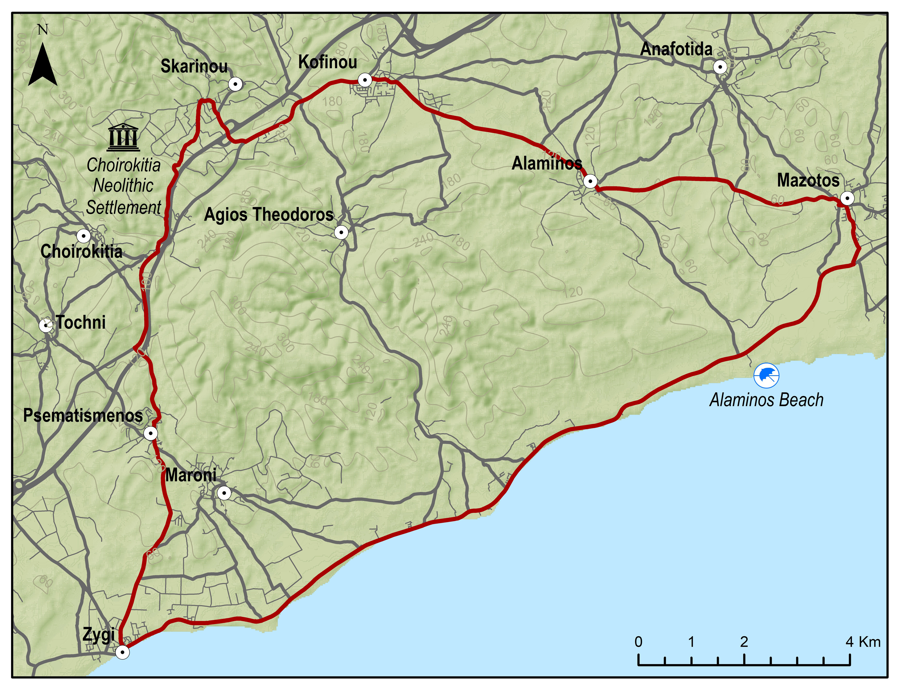
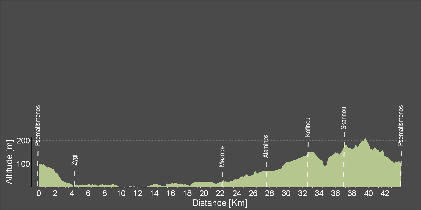
Psematismenos - Zygi - Mazotos - Alaminos - Kofinou - Psematismenos
Zunächst geht es nach Zygi und zur Küste auf dieser Rundfahrt durch das südliche Maroni-Tal, einem vor Urzeiten zentralen Siedlungsraum. Wichtige archäologische Funde wurden hier gemacht. Entlang des Meeres, über Mazotos und Alaminos geht es Iangsam, aber stetig hinauf in das reizende Dorf Skarinou in den Ausläufern der "Lefka Ori" (weißen Berge), die Lefkara seinen Namen gaben. Von hier sind es kaum sechs Kilometer zurück durch die Landschaft dieses zeitlosen Tales.
Bitte klicken sie hier zum download die beschreibung der route.
Bitte klicken sie hier zum download die route im gpx-format.
| Distance: | 43.2km |
| Elevation Gain: | 326m |
| Highest point: | 210m |
| Lowest point: | 0 |
| Loop: | YES |
| Terrain: | Flat |
| Road surface: | Paved |
| Section Distance (km) | Total Distance (km) | |
| Psematismenos | 0.0 | 0.0 |
| Zygi | 4.1 | 4.1 |
| Mazotos | 18.1 | 22.2 |
| Alaminos | 5.5 | 27.7 |
| Kofinou | 4.8 | 32.5 |
| Skarinou | 4.1 | 36.6 |
| Psematismenos | 6.6 | 43.2 |
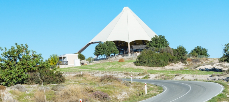
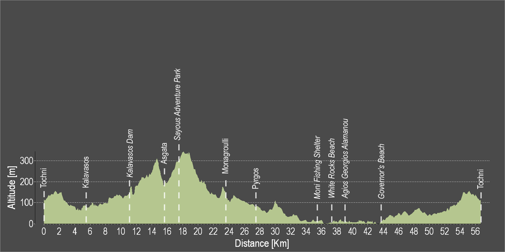
The route starts from the beautiful Tochni and heads towards Kalavasos. At a short distance from Kalavasos lies the Tenta Neolithic Settlement dating back to 7000 BC. It is one of the most important Neolithic Settlements on the island and is sheltered by a distinctive cone-shaped roof, which is a contemporary architectural intervention in the landscape. Subsequently, the route ascends towards the Kalavasos Reservoir. Next, discover the village of Asgata, then continue uphill to the adventure theme park and downhill again to Monagroulli and Pyrgos. The route continues along the coast, passing by the Moni Fishing Shelter, the impressive White Rocks coastal area, the beach of Agios Georgios Alamanos and the Governor's Beach, to then head uphill and end in Tochni.
To download the route in gpx format click here
| Distance: | 56.9km |
| Elevation Gain: | 864m |
| Highest point: | 355m |
| Lowest point: | 0m |
| Loop: | YES |
| Terrain: | Mixed |
| Section Distance (km) | Total Distance (km) | |
| Tochni | 0.0 | 0.0 |
| Kalavasos | 5.5 | 5.5 |
| Kalavasos Dam | 6.3 | 11.8 |
| Asgada | 4.5 | 16.3 |
| Sayous Adventure Park | 1.9 | 18.2 |
| Monagrouli | 5.9 | 24.1 |
| Pyrgos | 4.1 | 28.2 |
| Moni Fishing Shelter | 7.8 | 36.0 |
| White Rocks Beach | 2.0 | 38.0 |
| Agios Georgios Alamanos Beach | 1.1 | 39.1 |
| Governor's Beach | 4.3 | 43.4 |
| Tochni | 13.5 | 56.9 |