Menu

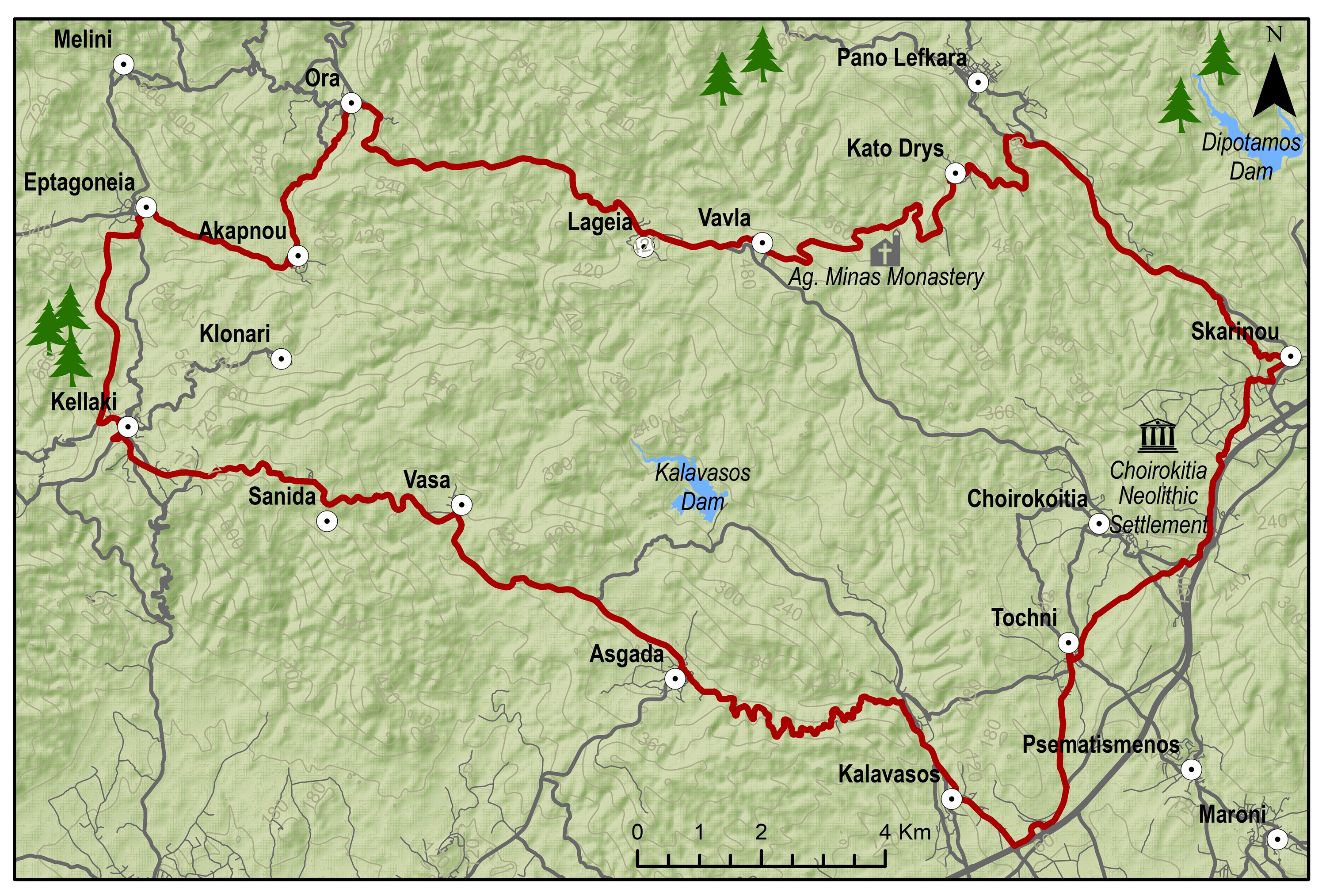
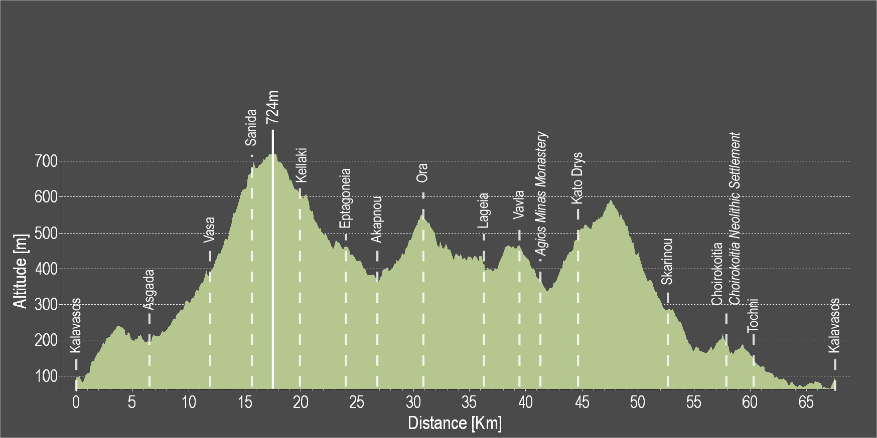
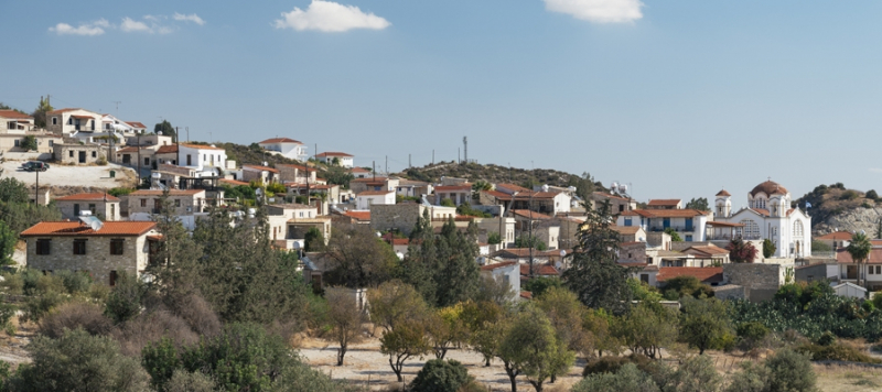
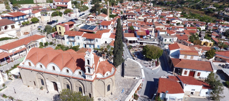
The route starts from the village of Kalavasos with a slight uphill ascent towards the village of Asgata. Pass through the narrow streets of the village and continue uphill to Vasa, Sanida and then to Kellaki. Woodland areas and unique views will be encountered along the way. Ride downhill to reach the Eptagoneia Village and the small picturesque village of Akapnou. Continue towards Ora, Lageia, Vavla and then ride uphill to Kato Drys village. A big downhill ride will follow which leads to the village of Skarinou. Pass through the village and continue to Choirokoitia and then to beautiful Tochni. Continue straight ahead to reach the starting point of the route in Kalavasos.
To download the route in gpx format click here
| Distance: | 67.3km |
| Elevation Gain: | 1484m |
| Highest point: | 724m |
| Lowest point: | 65m |
| Loop: | YES |
| Terrain: | Mountain |
| Road surface: | Paved |
| Section Distance (km) | Total Distance (km) | |
| Kalavasos | 0.0 | 0.0 |
| Asgada | 6.6 | 6.6 |
| Vasa | 5.1 | 11.7 |
| Sanida | 3.6 | 15.3 |
| Kellaki | 4.1 | 19.4 |
| Eptagoneia | 4.5 | 23.9 |
| Akapnou | 3.0 | 26.9 |
| Ora | 3.5 | 30.4 |
| Lageia | 6.3 | 36.7 |
| Vavla | 2.4 | 39.1 |
| Agios Minas Monastery | 2.4 | 41.5 |
| Kato Drys | 3.1 | 44.6 |
| Skarinou | 9.0 | 53.6 |
| Choirokoitia | 4.1 | 57.7 |
| Choirokoitia Neolithic Settlement | 0.0 | 57.7 |
| Tochni | 2.7 | 60.4 |
| Kalavasos | 6.9 | 67.3 |
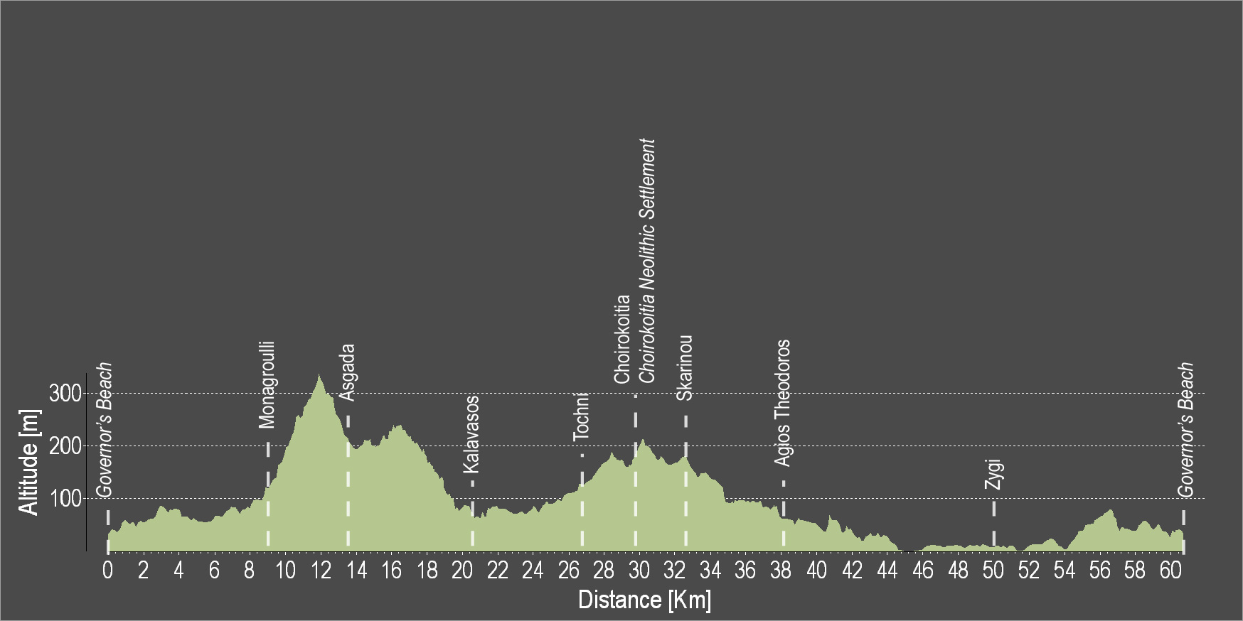
The route starts at the Governor's Beach heading west to Monagroulli. A three kilometre uphill ride will lead to the beautiful village of Asgata. Pass through the narrow streets of the village and go downward to Kalavasos. The paved traditional streets, the grand church of the Virgin Mary and the Mosque are some of the many things to admire in Kalavasos. Then, head south and discover the village of Tochni where the ancient church of the village is bound to impress. The village of Choirokoitia is next, where the Neolithic Settlement of Choirokoitia is located, which has been listed as a UNESCO World Heritage Site since 1998. Skarinou and Agios Theodoros are the villages to follow before reaching Zygi and the Zygi Marina. Continue towards Vasiliko to finish the circular route at Governor’s Beach.
To download the route in gpx format click here
| Distance: | 60.2km |
| Elevation Gain: | 806m |
| Highest point: | 336m |
| Lowest point: | 3m |
| Loop: | YES |
| Terrain: | Mixed |
| Road surface: | Paved |
| Section Distance (km) | Total Distance (km) | |
| Governor's Beach | 0.0 | 0.0 |
| Monagrouli | 8.5 | 8.5 |
| Asgada | 5.1 | 13.6 |
| Kalavasos | 6.7 | 20.3 |
| Tochni | 6.1 | 26.4 |
| Choirokoitia | 3.0 | 29.4 |
| Choirokoitia Neolithic Settlement | 0.0 | 29.4 |
| Skarinou | 3.1 | 32.5 |
| Agios Theodoros | 5.3 | 37.8 |
| Zygi | 12.4 | 50.2 |
| Governor's Beach | 10.0 | 60.2 |

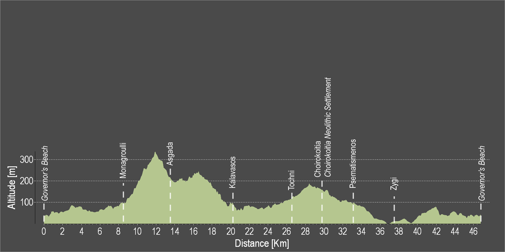
The route starts at the Governor's Beach and heads westward to Monagroulli. A three kilometre uphill ride will lead to the beautiful village of Asgata. Pass through the narrow streets of the village and go downward to Kalavasos. The paved traditional streets, the grand church of the Virgin Mary and the Mosque are some of the many things to admire in Kalavasos. Then, head south and discover the village of Tochni where the ancient church of the village is bound to impress. Choirokoitia and Psematismenos are the villages to follow before reaching Zygi and the Zygi Marina. Continue towards Vasiliko to finish the circular route at Governor’s Beach.
To download the route in gpx format click here
| Distance: | 47.2km |
| Elevation Gain: | 677m |
| Highest point: | 338m |
| Lowest point: | 3m |
| Loop: | YES |
| Terrain: | Mixed |
| Road surface: | Paved |
| Section Distance (km) | Total Distance (km) | |
| Governor's Beach | 0,0 | 0,0 |
| Monagroulli | 8.5 | 8.5 |
| Asgada | 5.1 | 13.6 |
| Kalavasos | 6.7 | 20.3 |
| Tochni | 6.1 | 26.4 |
| Choirokoitia | 3.0 | 29.4 |
| Choirokoitia Neollithic Settlement | 0.0 | 29.4 |
| Psematismenos | 3.3 | 32.7 |
| Zygi | 4.5 | 37.2 |
| Governor's Beach | 10.0 | 47.2 |