Menu


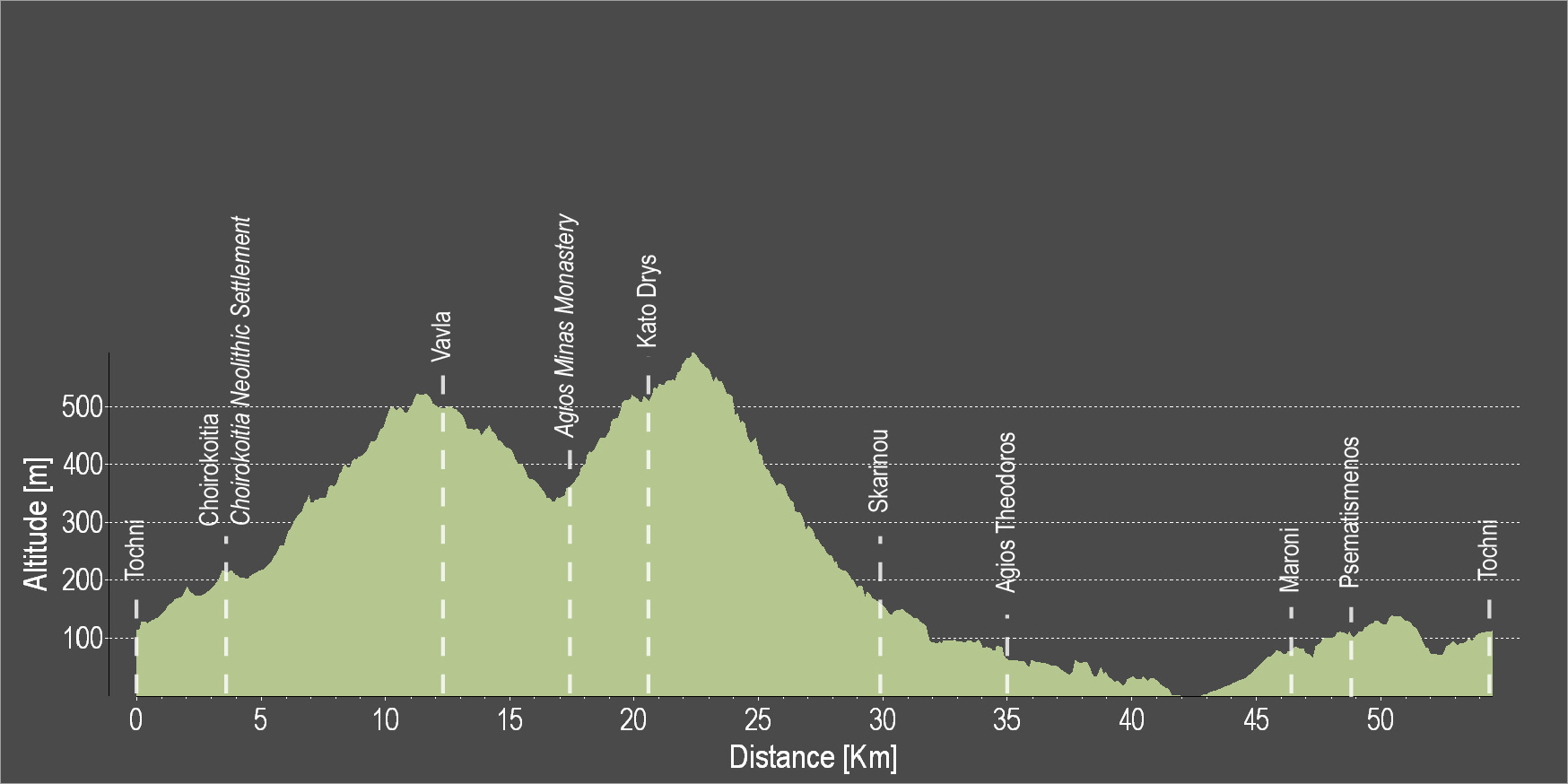
The route starts in beautiful Tochni and heads to Choirokoitia where the Neolithic Settlement of Choirokoitia is located, which has been registered as a UNESCO World Heritage Site since 1998. Next, it ascends to Vavla, a designated heritage village due to its white stone houses and its traditional features. Then, the route descends to reach the Monastery of Agios Minas and ascends again heading towards the idyllic and picturesque Kato Drys. The route then descends to Skarinou, and continues onward to the beautiful villages of Agios Theodoros, Maroni and Psematismenos to reach the starting point in Tochni.
To download the route in gpx format click here
| Distance: | 54.2km |
| Elevation Gain: | 927m |
| Highest point: | 583m |
| Lowest point: | 3m |
| Loop: | YES |
| Terrain: | Mixed |
| Road surface: | Paved |
| Section Distance (km) | Total Distance (km) | |
| Tochni | 0.0 | 0.0 |
| Choirokoitia | 3.8 | 3.8 |
| Choirokoitia Neolithic Settlement | 0 | 3.8 |
| Vavla | 9 | 12.8 |
| Agios Minas Monastery | 4.1 | 16.9 |
| Kato Drys | 3.6 | 20.5 |
| Skarinou | 9.5 | 30.0 |
| Agios Theodoros | 4.8 | 34.8 |
| Maroni | 11.3 | 46.1 |
| Psematismenos | 1.7 | 47.8 |
| Tochni | 6.4 | 54.2 |
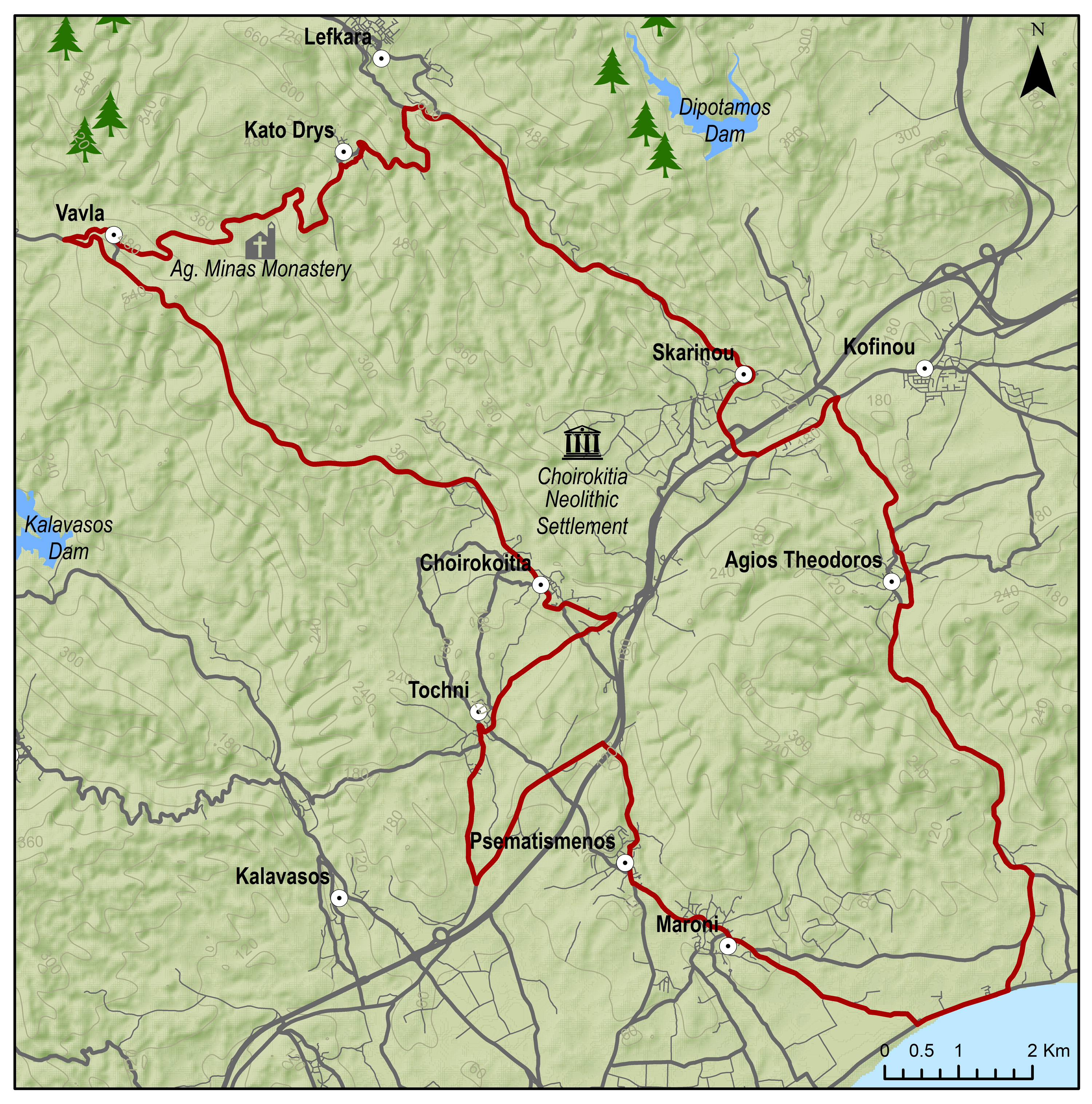
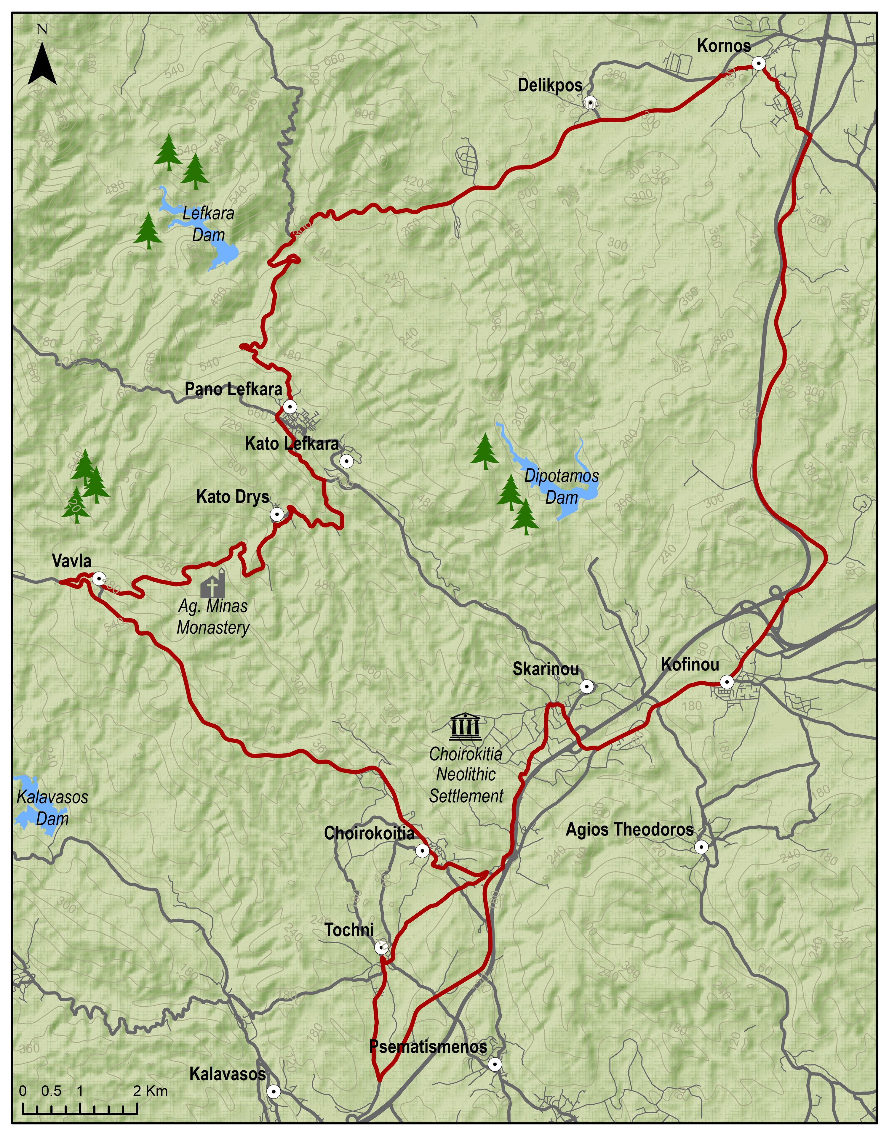
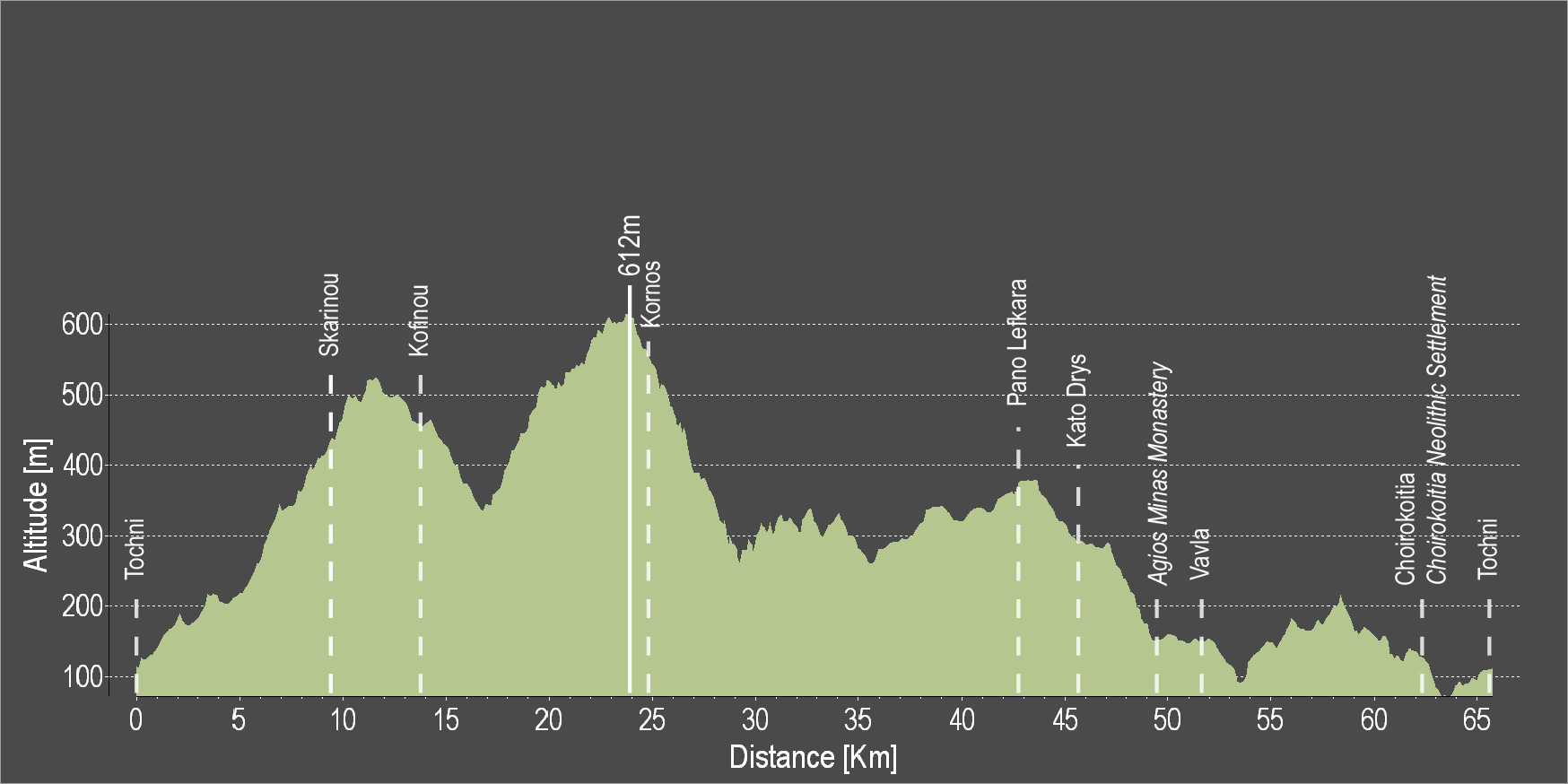
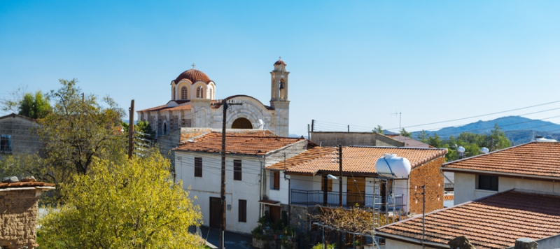
The route starts in beautiful Tochni and heads to Choirokoitia where the Neolithic Settlement of Choirokoitia is located, which has been registered as a UNESCO World Heritage Site since 1998. Next, it ascends to Vavla, a designated heritage village due to its white stone houses and its traditional features. Then, the route descends to reach the Monastery of Agios Minas and ascends again heading towards the idyllic and picturesque Kato Drys and then to Lefkara, known for its traditional embroidered lace and silver wire crafts. The route continues downhill to Kornos, renowned for its traditional handmade clay vessels, as well as for its tradition in beekeeping, as it produces superior quality honey. Then the route leads uphill through the mountain breeze to the Holy Monastery of Stavrovouni built on a rocky peak. Then you can head down to Kofinou, Skarinou to finally return to Tochni.
To download the route in gpx format click here
| Distance: | 65.7km |
| Elevation Gain: | 1136m |
| Highest point: | 612m |
| Lowest point: | 72m |
| Loop: | YES |
| Terrain: | Mountain |
| Road surface: | Paved |
| Section Distance (km) | Total Distance (km) | |
| Tochni | 0.0 | 0.0 |
| Skarinou | 9.9 | 9.9 |
| Kofinou | 3.9 | 13.8 |
| Kornos | 11.8 | 25.6 |
| Pano Lefkara | 16.3 | 41.9 |
| Kato Drys | 3.6 | 45.5 |
| Agios Minas Monastery | 3.8 | 49.3 |
| Vavla | 2.3 | 51.6 |
| Choirokoitia | 10.5 | 62.1 |
| Choirokoitia Neolithic Settlement | 0 | 62.1 |
| Tochni | 3.6 | 65.7 |
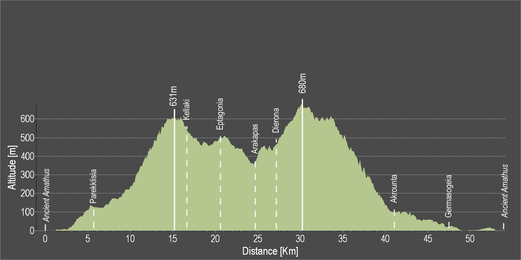
The route starts from the ancient city of Amathous. Ride along the beach until the turn towards Parekklisia village where there is an uphill climb. Pass through the village and continue uphill. The Lemesos Quarry is on the left and across are the mountains of Olympos. Continue and cross the village of Kellaki where the route will start to descend and reach the Eptagoneia Village. Head left and proceed towards the Arakapas and Dierona villages, while entering a very beautiful pine grove. Next up, pass by Akrounta and the Germasogeia Reservoir to reach the village of Germasogeia and continue along the coast in order to end the route and reach Amathous again.
To download the route in gpx format click here
| Distance: | 53.9km |
| Elevation Gain: | 1188m |
| Highest point: | 692m |
| Lowest point: | 33m |
| Loop: | YES |
| Terrain: | Mountain |
| Road surface: | Paved |
| Section Distance (km) | Total Distance (km) | |
| Ancient Amathus | 0,0 | 0,0 |
| Parekklisia | 5.8 | 5.8 |
| Kellaki | 10.5 | 16.3 |
| Eptagonia | 4.2 | 20.5 |
| Arakapas | 4.2 | 24.7 |
| Dierona | 2.3 | 27.0 |
| Akrounta | 14.6 | 41.6 |
| Germasogia | 5.8 | 47.4 |
| Ancient Amathus | 6.5 | 53.9 |