Menu

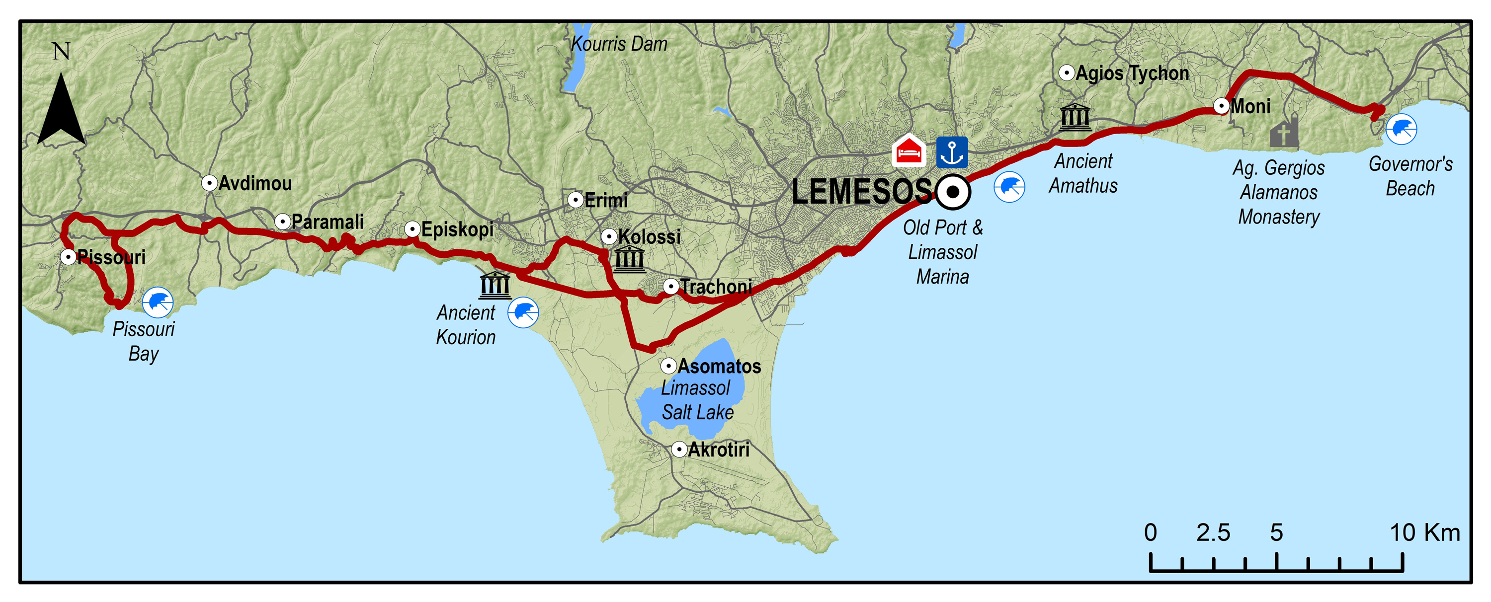
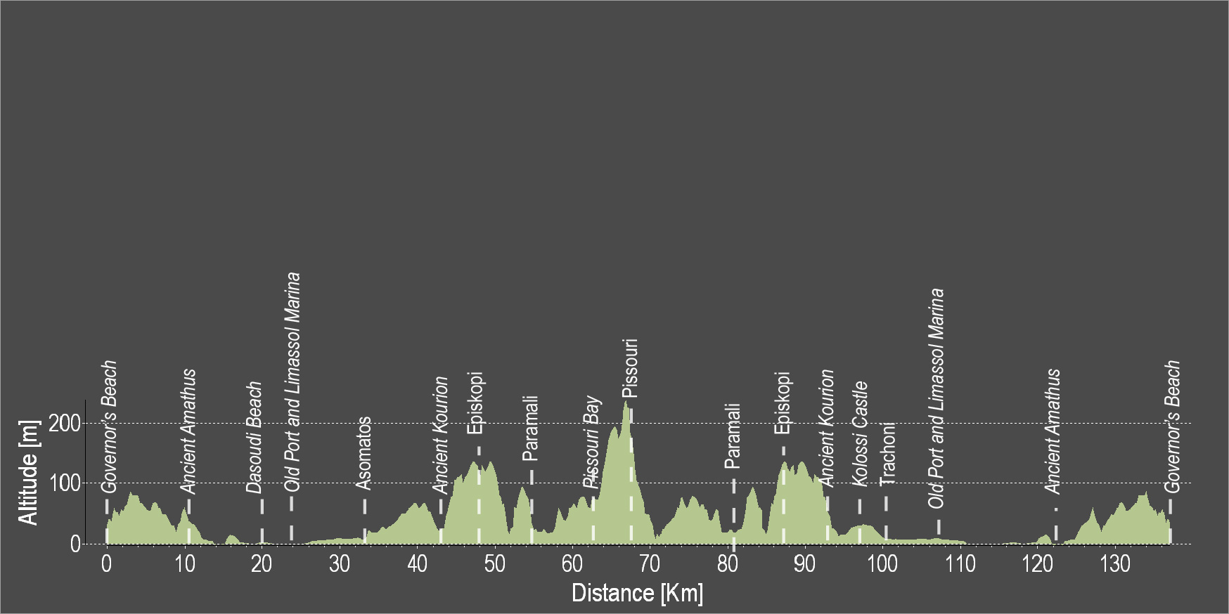
The route starts from Governor's Beach and heads towards the coast and westward towards Lemesos. Cross Lemesos by going along the entire coastline of the city, from the Molos area, to the old port, to Limassol Marina, etc. Continue west and pass through the archaeological site of Kourion where the ancient theatre of Kourion is located. Ride uphill to the Sanctuary of Apollon Hylates and continue to reach the Episkopi and the Happy Valley. Pass through the Paramali village and end the route in Pissouri and Pissouri Bay.
To download the route in gpx format click here
| Distance: | 131.2km |
| Elevation Gain: | 1191m |
| Highest point: | 241m |
| Lowest point: | 2m |
| Loop: | YES |
| Terrain: | Mixed |
| Road surface: | Paved |
| Section Distance (km) | Total Distance (km) | |
| Governor's Beach | 0,0 | 0,0 |
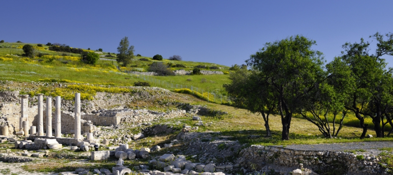
| Ancient Amathus | 10.5 | 10.5 |
| Dasoudi Beach | 9.5 | 20.0 |
| Old Port | 4.3 | 24.3 |
| Limassol Marina | 0.6 | 24.9 |
| asomatos | 8.2 | 33.1 |
| Ancient Kourion | 9.5 | 42.6 |
| Episkopi | 4.9 | 47.5 |
| Paramali | 5.6 | 53.1 |
| Pissouri Bay | 10.5 | 63.6 |
| Pissouri | 3.3 | 66.9 |
| Paramali | 11.5 | 78.4 |
| Episkopi | 5.5 | 83.9 |
| Ancient Kourion | 5 | 88.9 |
| Kolossi Castle | 5.5 | 94.4 |
| Trachoni | 4.6 | 99 |
| Limassol Marina | 7.2 | 106.2 |
| Old Port | 0.6 | 106.8 |
| Dasoudi Beach | 4.3 | 111.1 |
| Ancient Amathus | 10.5 | 121.6 |
| Governor's Beach | 9.6 | 131.2 |
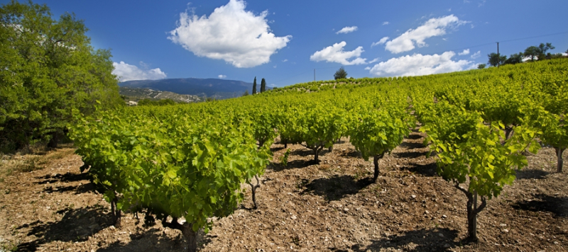
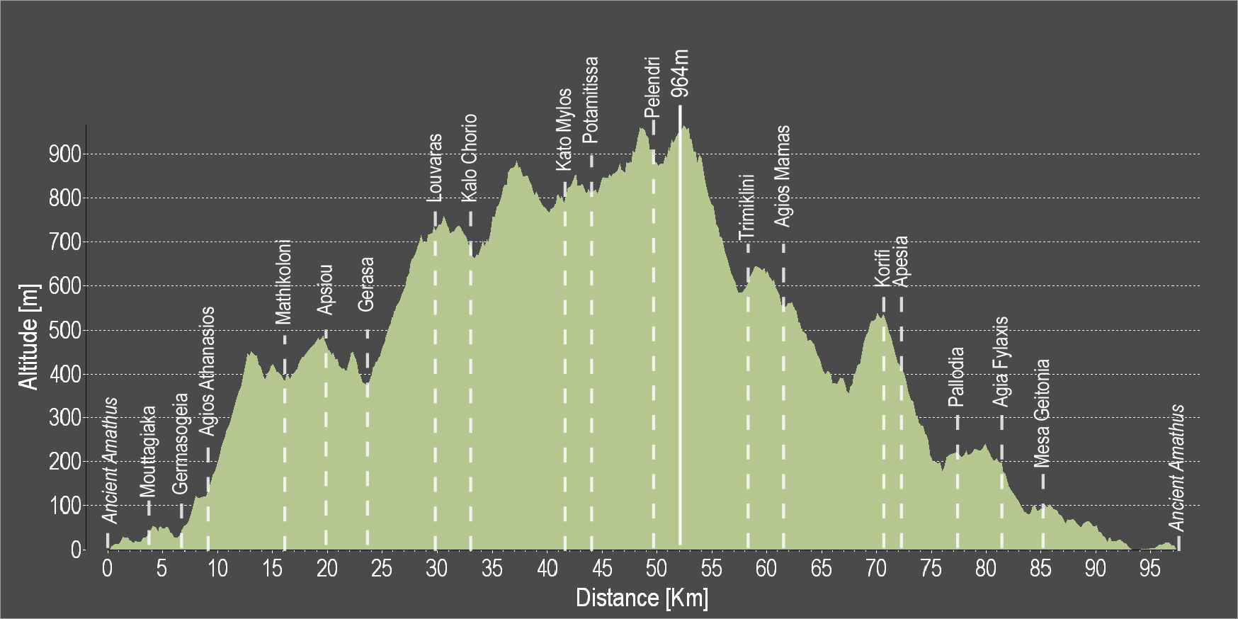
The route starts from Amathous, crosses Germasogeia and ascends to Mathikoloni. Apsiou and Gerasa are the next two villages to encounter before reaching Kalo Chorio. Then, after passing by a pine grove the route leads further north to the picturesque village of Potamitissa and then to the largest village in the area, Pelendri. A big downhill ride will lead to Saittas and from there go uphill to Agios Mamas, Kapileio, Korfi and Paramytha. Palodeia is the last village to come upon before reaching Lemesos and heading to the starting point in Amathous.
To download the route in gpx format click here
| Distance: | 97.2km |
| Elevation Gain: | 2112m |
| Highest point: | 964m |
| Lowest point: | 1m |
| Loop: | YES |
| Terrain: | Mountain |
| Road surface: | Paved |
| Section Distance (km) | Total Distance (km) | |
| Ancient Amathus | 0,0 | 0,0 |
| Mouttagiaka | 4.0 | 4.0 |
| Germasogia | 2.1 | 6.1 |
| Agios Athanasios | 2.5 | 8.6 |
| Mathikoloni | 8.0 | 16.6 |
| Apsiou | 3.4 | 20.0 |
| Gerasa | 3.4 | 23.4 |
| Louvaras | 6.2 | 29.6 |
| Kalo Chorio | 2.7 | 32.3 |
| Kato Mylos | 8.8 | 41.1 |
| Potamitissa | 3 | 44.1 |
| Pelendri | 5.6 | 49.7 |
| Trimiklini | 8.5 | 58.2 |
| Agios Mamas | 3.6 | 61.8 |
| Korifi | 8.6 | 70.4 |
| Apesia | 1.5 | 71.9 |
| Pallodia | 6 | 77.9 |
| Agia Fylaxis | 3.5 | 81.4 |
| Mesa Geitonia | 3.5 | 84.9 |
| Ancient Amathus | 12.3 | 97.2 |

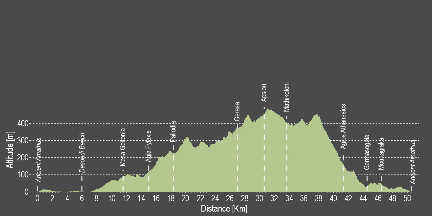
The route starts from the ancient Amathous and is directed toward Lemesos. Head towards Agia Fyla and then go uphill towards Palodeia. Pass outside the village of Gerasa and enter a pine grove leading towards the small village of Apsiou. Ride uphill towards Mathikoloni and then pass through the village of Germasogeia. Mouttagiaka is the last village on the route before reaching the Germasogeia Tourist Area and the starting point in Amathous.
To download the route in gpx format click here
| Distance: | 50.3km |
| Elevation Gain: | 881m |
| Highest point: | 500m |
| Lowest point: | 1m |
| Loop: | YES |
| Terrain: | Mixed |
| Road surface: | Paved |
| Section Distance (km) | Total Distance (km) | |
| Ancient Amathus | 0,0 | 0,0 |
| Dasoudi Beach | 6.0 | 6.0 |
| Mesa Geitonia | 5.6 | 11.6 |
| Agia Fylaxis | 3.5 | 15.1 |
| Pallodia | 3.5 | 18.6 |
| Gerasa | 8.3 | 26.9 |
| Apsiou | 3.4 | 30.3 |
| Mathikoloni | 3.4 | 33.7 |
| Agios Athanasios | 8.0 | 41.7 |
| Germasogeia | 2.5 | 44.2 |
| Mouttagiaka | 2.1 | 46.3 |
| Ancient Amathus | 4.0 | 50.3 |