Menu

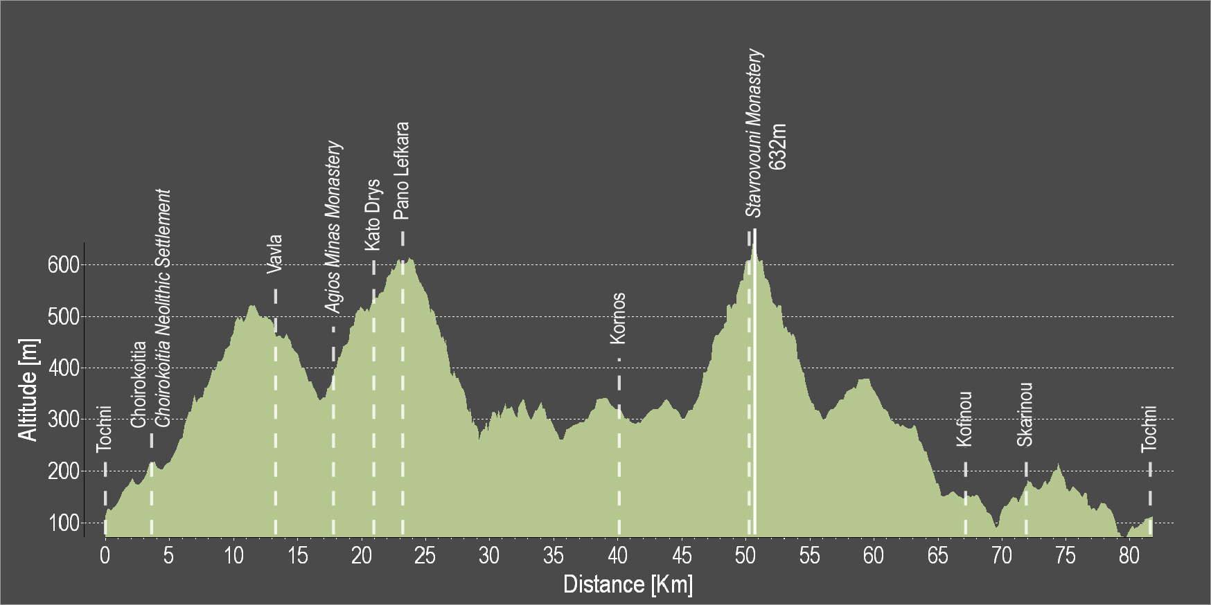
The route starts from the beautiful Tochni and heads towards the villages of Skarinou and Kofinou, before ascending to Kornos, renowned for its traditional handmade clay vessels, as well as for its tradition in beekeeping, as it produces superior quality honey. After a ride of about 20 kilometres in the mountainous Larnaka, you encounter Lefkara, known for its traditional embroidered lace and silver wire crafts. Next up is the beautiful Kato Drys, the Monastery of Agios Minas and Vavla, a designated heritage village due to its white stone houses and its traditional features. The route continues towards Choirokoitia, where the Neolithic Settlement of Choirokoitia is located, which has been registered as a UNESCO World Heritage Site since 1998, and ends in beautiful Tochni.
To download the route in gpx format click here
| Distance: | 81.7km |
| Elevation Gain: | 1554m |
| Highest point: | 632m |
| Lowest point: | 74m |
| Loop: | YES |
| Terrain: | Mountain |
| Road surface: | Paved |
| Section Distance (km) | Total Distance (km) | |
| Tochni | 0.0 | 0.0 |
| Choirkoitia | 3.8 | 3.8 |
| Choirokoitia Neolithic Settlement | 0 | 3.8 |
| Vavla | 9 | 12.8 |
| Agios Minas Monastery | 4.1 | 16.9 |
| Kato Drys | 3.6 | 20.5 |
| Pano Lefkara | 3.2 | 23.7 |
| Kornos | 16.1 | 39.8 |
| Stavrovouni Monastery | 10.7 | 50.5 |
| Kofinou | 17.3 | 67.8 |
| Skarinou | 4 | 71.8 |
| Tochni | 9.9 | 81.7 |

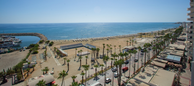
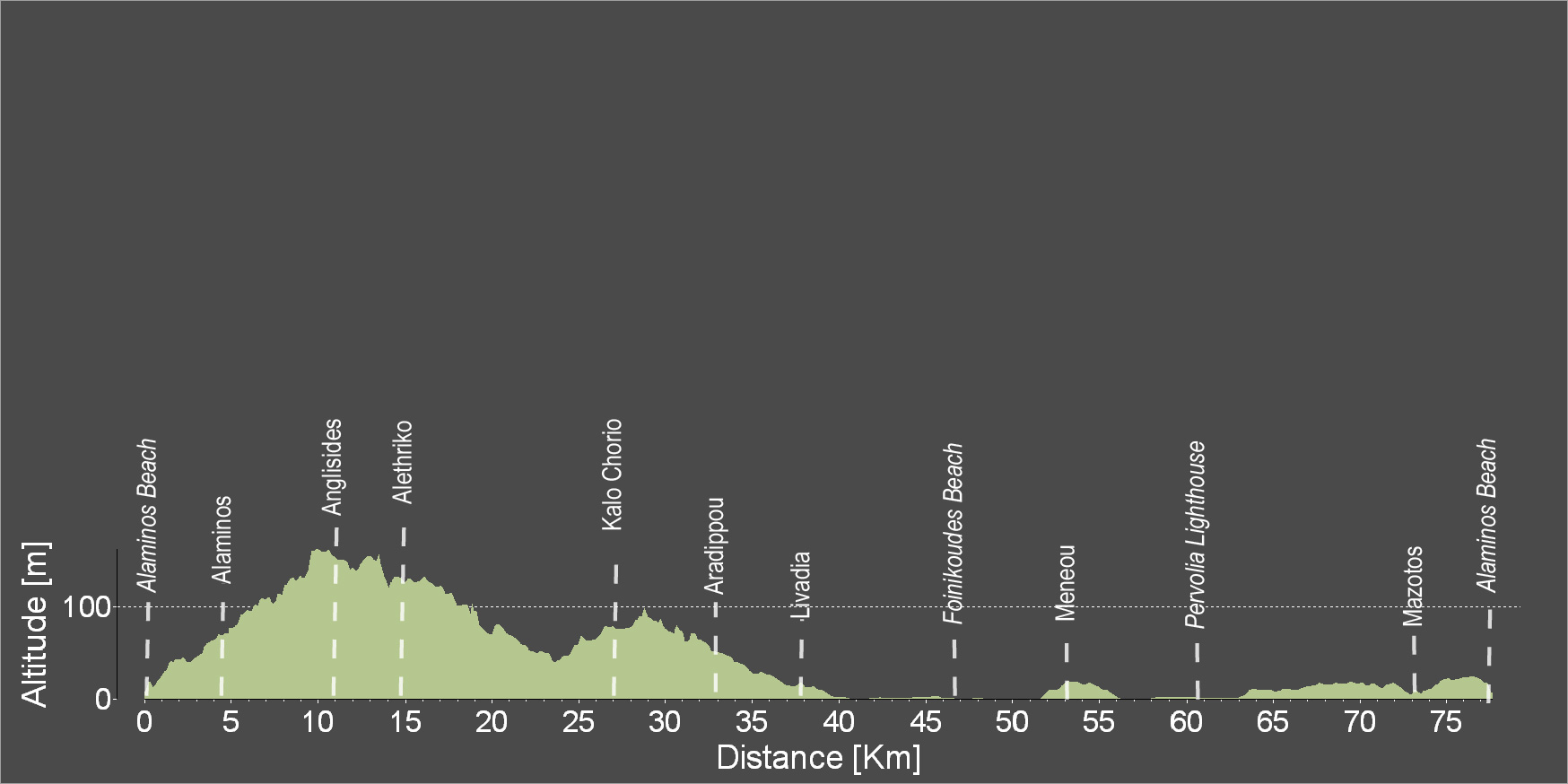
The route starts from the village of Mazotos - Alaminos and heads to Anglisides and Alethriko. Pass over the bridge and head towards Kalo Chorio, then find Aradippou, which is one of the largest villages on this route, and then head towards Livadia and enter the coastal road of Larnaka. Ride along the Foinikoudes area and enjoy the beautiful beach. Pass by the Mackenzie cosmopolitan area with its many cafes and bars and then head towards the old Larnaka airport. Cross the salt lake and continue towards Meneou and the beautiful Lighthouse.
To download the route in gpx format click here
| Distance: | 77.0km |
| Elevation Gain: | 306m |
| Highest point: | 163m |
| Lowest point: | 0 |
| Loop: | YES |
| Terrain: | Flat |
| Road surface: | Paved |
| Section Distance (km) | Total Distance (km) | |
| Alaminos Beach | 0.0 | 0.0 |
| Alaminos | 4.4 | 4.4 |
| Anglisides | 6.2 | 10.6 |
| Alethriko | 3.8 | 14.4 |
| Kalo Chorio | 11.8 | 26.2 |
| Aradippou | 6.7 | 32.9 |
| Livadia | 5 | 37.9 |
| Foinikoudes Beach | 8.6 | 46.5 |
| Meneou | 6.8 | 53.3 |
| Pervolia Lighthouse | 7.2 | 60.5 |
| Mazotos | 13.2 | 73.7 |
| Alaminos Beach | 3.3 | 77 |

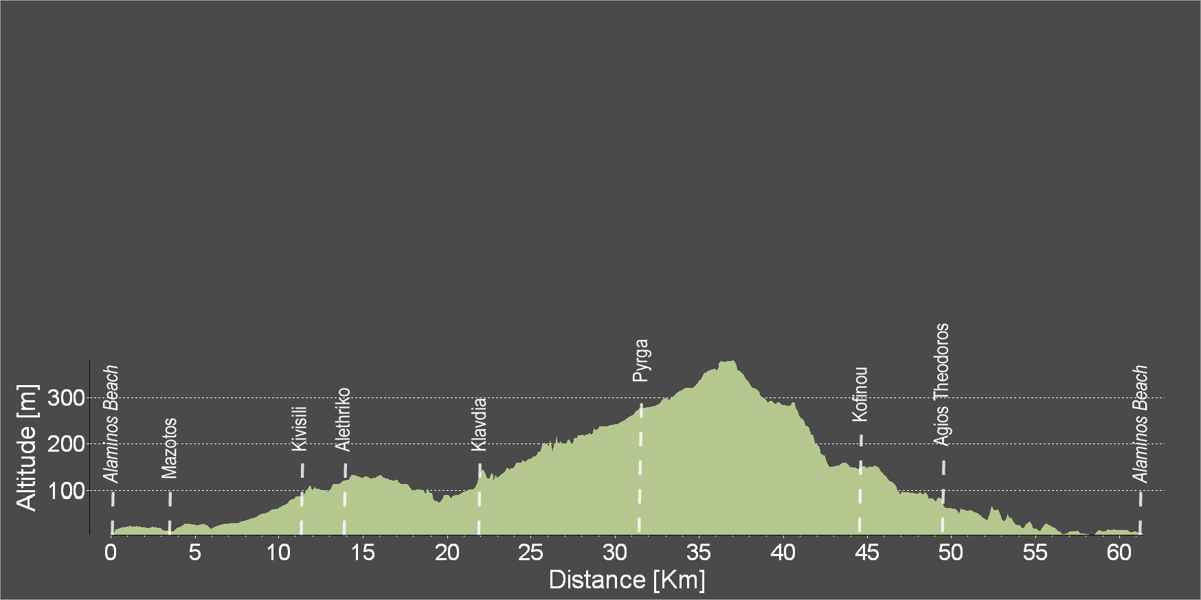
The route starts off at Alaminos beach and gradually ascends while passing through the villages of Mazotos, Alethriko, Klavdia and Pyrga and then circles back downhill towards Kofinou and the beautiful village of Agios Theodoros to reach Alaminos beach.
To download the route in gpx format click here
| Distance: | 60.9km |
| Elevation Gain: | 491m |
| Highest point: | 376m |
| Lowest point: | 6m |
| Loop: | YES |
| Terrain: | Mixed |
| Road surface: | Paved |
| Section Distance (km) | Total Distance (km) | |
| Alaminos Beach | 0.0 | 0.0 |
| Mazotos | 3.8 | 3.8 |
| Kivisili | 7.1 | 10.9 |
| Alethriko | 2.7 | 13.6 |
| Klavdia | 7.7 | 21.3 |
| Pyrga | 9.9 | 31.2 |
| Kofinou | 13.7 | 44.9 |
| Agios Theodoros | 4.3 | 49.2 |
| Alaminos Beach | 11.7 | 60.9 |