Menu

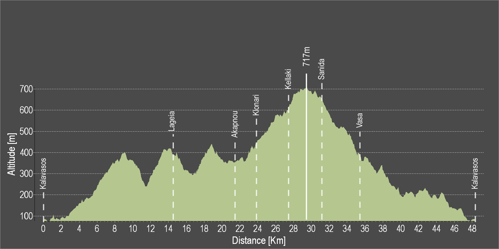
The route starts from the village of Kalavasos and goes uphill passing by the Kalavasos Reservoir. The route is circular, it is mostly on a dirt road and some parts of it require good technical cycling skills.
To download the route in gpx format click here
| Distance: | 46.8km |
| Elevation Gain: | 1167m |
| Highest point: | 717m |
| Lowest point: | 72m |
| Loop: | YES |
| Terrain: | Mountain |
| Section Distance (km) | Total Distance (km) | |
| Kalavasos | 0.0 | 0.0 |
| Lageia | 14.7 | 14.7 |
| Akapnou | 6.8 | 21.5 |
| Klonari | 2.4 | 23.9 |
| Kelaki | 3.1 | 27.0 |
| Sanida | 3.4 | 30.4 |
| Vasa | 5.0 | 35.4 |
| Kalavasos | 11.4 | 46.8 |

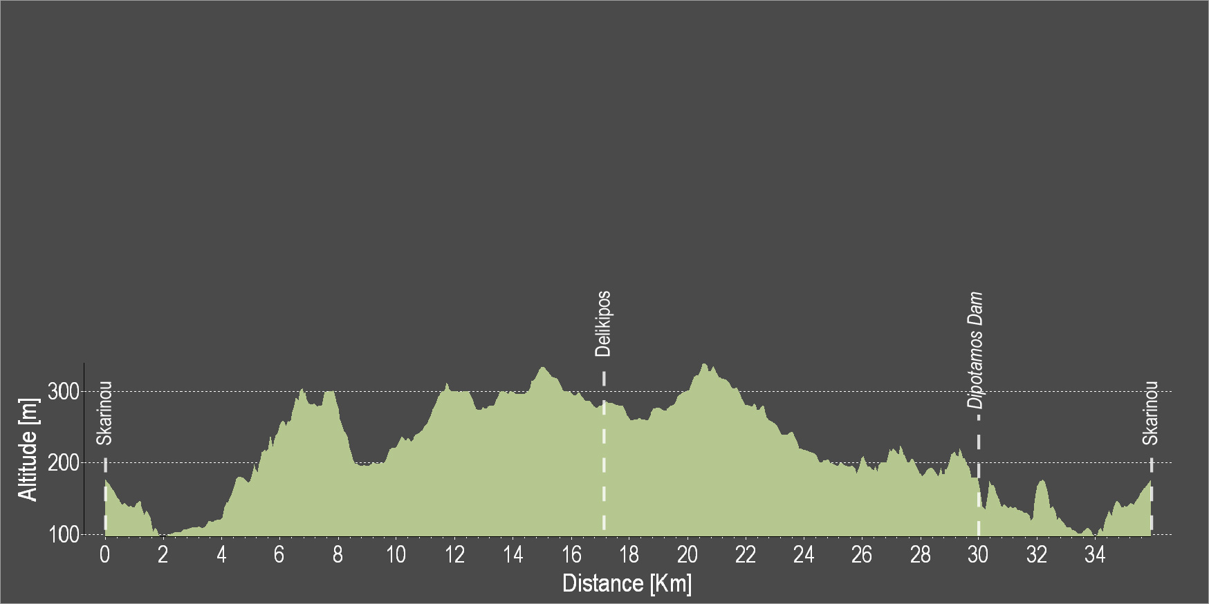
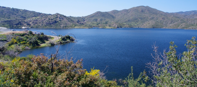
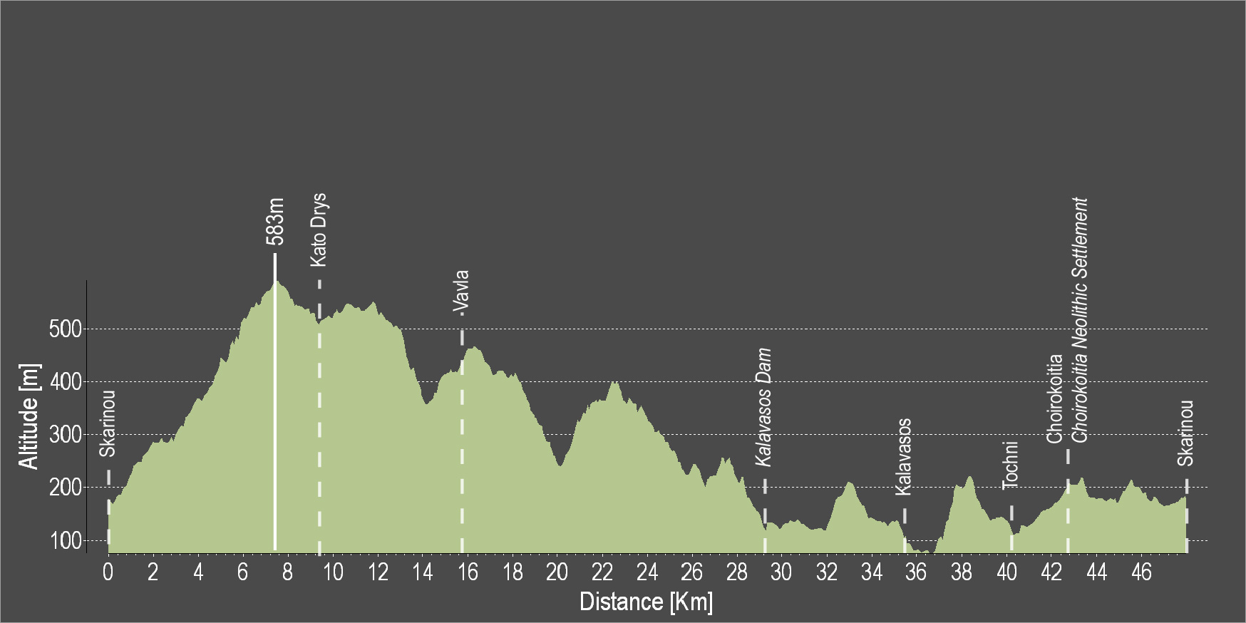
The route starts from the village of Skarinou, ascends to Kato Drys and then descends to Vavla, a designated heritage village due to its white stone houses and its traditional features. Continue towards the Kalavasos Reservoir and then to the picturesque villages of Kalavasos and Tochni. The route then heads to Choirokoitia, passing by the site where the Neolithic Settlement of Choirokoitia lies, which has been listed as a UNESCO World Heritage Site since 1998, and ends again in Skarinou
To download the route in gpx format click here
| Distance: | 48.0km |
| Elevation Gain: | 1182m |
| Highest point: | 583m |
| Lowest point: | 75m |
| Loop: | YES |
| Terrain: | Mountained |
| Section Distance (km) | Total Distance (km) | |
| Skarinou | 0.0 | 0.0 |
| Kato Drys | 9.8 | 9.8 |
| Vavla | 5.5 | 15.3 |
| Kalavasos Dam | 12.8 | 28.1 |
| Kalavasos | 7.8 | 35.9 |
| Tochni | 4.1 | 40.0 |
| Choirokoitia | 3.2 | 43.2 |
| Choirokoitia Neolithic Settlement | 0.0 | 43.2 |
| Skarinou | 4.8 | 48.0 |

The route starts from the village of Psematismenos and heads towards the chapel of Agios Andronikos and Agia Athanasia. Then, proceed downhill to Maroni and through rural roads towards the beach and the Secret Paradise Fishing Shelter. Continue along the coast and go uphill to Mazotos. Next, you will encounter the villages of Anafotida and Alaminos. The rural dirt roads lead to the village of Agios Theodoros where you can enter the main road and head to Choirokoitia. Cross the beautiful Tochni and enter a delightful path that leads to the main road. Pass under the highway and, via the dirt road, reach the starting point.
To download the route in gpx format click here
| Distance: | 51.8km |
| Elevation Gain: | 539m |
| Highest point: | 201m |
| Lowest point: | 0m |
| Loop: | YES |
| Terrain: | Mixed |
| Section Distance (km) | Total Distance (km) | |
| Psematismenos | 0.0 | 0.0 |
| Maroni | 2.3 | 2.3 |
| Alaminos Beach | 12.5 | 14.8 |
| Mazotos Beach | 5.0 | 19.8 |
| Mazotos | 4.3 | 24.1 |
| Anafotida | 3.4 | 27.5 |
| Alaminos | 3.3 | 30.8 |
| Agios Theodoros | 5.6 | 36.4 |
| Choirokoitia | 7.4 | 43.8 |
| Choirokoitia Neolithic Settlement | 0.0 | 43.8 |
| Tochni | 2.4 | 46.2 |
| Psematismenos | 5.6 | 51.8 |