Menu

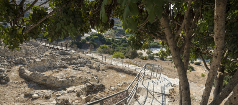
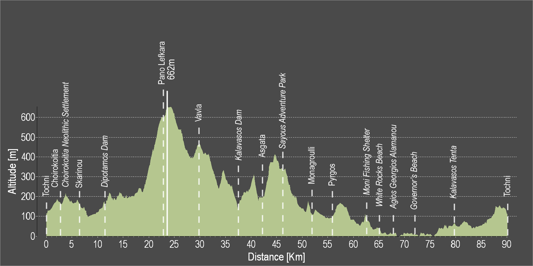
The route starts from the beautiful Tochni and heads to Choirokoitia, where the Neolithic Settlement of Choirokoitia lies, which has been listed as a UNESCO World Heritage Site since 1998. Continue onwards to the village of Skarinou and the Dipotamos Reservoir before heading downhill to the village of Lefkara, known for its traditional embroidered lace and silver wire crafts. The route proceeds to the village of Vavla, the Kalavasos Reservoir and the village of Asgata, before passing by the adventure theme park, and then descend to Monagroulli and Pyrgos. Continue along the coast, passing by the Moni Fishing Shelter, the impressive White Rocks coastal area, the beach of Agios Georgios Alamanos and the Governor's Beach. Before reaching Tochni, you can pass by the Tenta Neolithic Settlement dating back to 7000 BC. It is one of the most important Neolithic Settlements on the island and is sheltered by a distinctive cone-shaped roof, which is a contemporary architectural intervention in the landscape.
To download the route in gpx format click here
| Distance: | 90.9km |
| Elevation Gain: | 1811m |
| Highest point: | 662m |
| Lowest point: | 0m |
| Loop: | YES |
| Terrain: | Mountain |
| Section Distance (km) | Total Distance (km) | |
| Tochni | 0.0 | 0.0 |
| Choirokoitia | 2.2 | 2.2 |
| Choirkoitia Neolithic Settlement | 0.0 | 2.2 |
| Skarinou | 4.8 | 7.0 |
| Dipotamos Dam | 4.8 | 11.8 |
| Pano Lefkara | 10.9 | 22.7 |
| Vavla | 6.9 | 29.6 |
| Kalavasos Dam | 8.4 | 38.0 |
| Asgada | 4.2 | 42.2 |
| Sayous Adventure Park | 4.1 | 46.3 |
| Monagrouli | 6.0 | 52.3 |
| Pyrgos | 8.7 | 61.0 |
| Moni Fishing Shelter | 7.8 | 68.8 |
| White Rocks Beach | 2.0 | 70.8 |
| Agios Georgios Alamanos Beach | 1.1 | 71.9 |
| Kalavasos Tenta | 12.7 | 84.6 |
| Tochni | 6.3 | 90.9 |

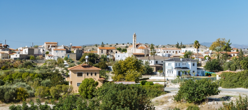
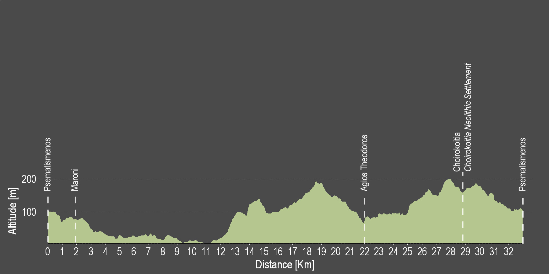
The route starts from the Psematismenos village, passes through the village of Maroni and heads south towards the beach. Then, it heads uphill through the rural roads where you can admire the beautiful views of the area. Reach the village of Agios Theodoros and head to Choirokoitia via the main road head and pass by the prehistoric settlement of the Neolithic period. Continue the route and end at the starting point.
To download the route in gpx format click here
| Distance: | 32.5km |
| Elevation Gain: | 486m |
| Highest point: | 212m |
| Lowest point: | 2m |
| Loop: | YES |
| Terrain: | FLAT |
| Section Distance (km) | Total Distance (km) | |
| Psematismenos | 0.0 | 0.0 |
| Maroni | 1.7 | 1.7 |
| Agios Theodoros | 19.5 | 21.2 |
| Choirokoitia | 7.6 | 28.8 |
| Choirokoitia Neolithic Settlement | 0.0 | 28.8 |
| Psematismenos | 3.7 | 32.5 |

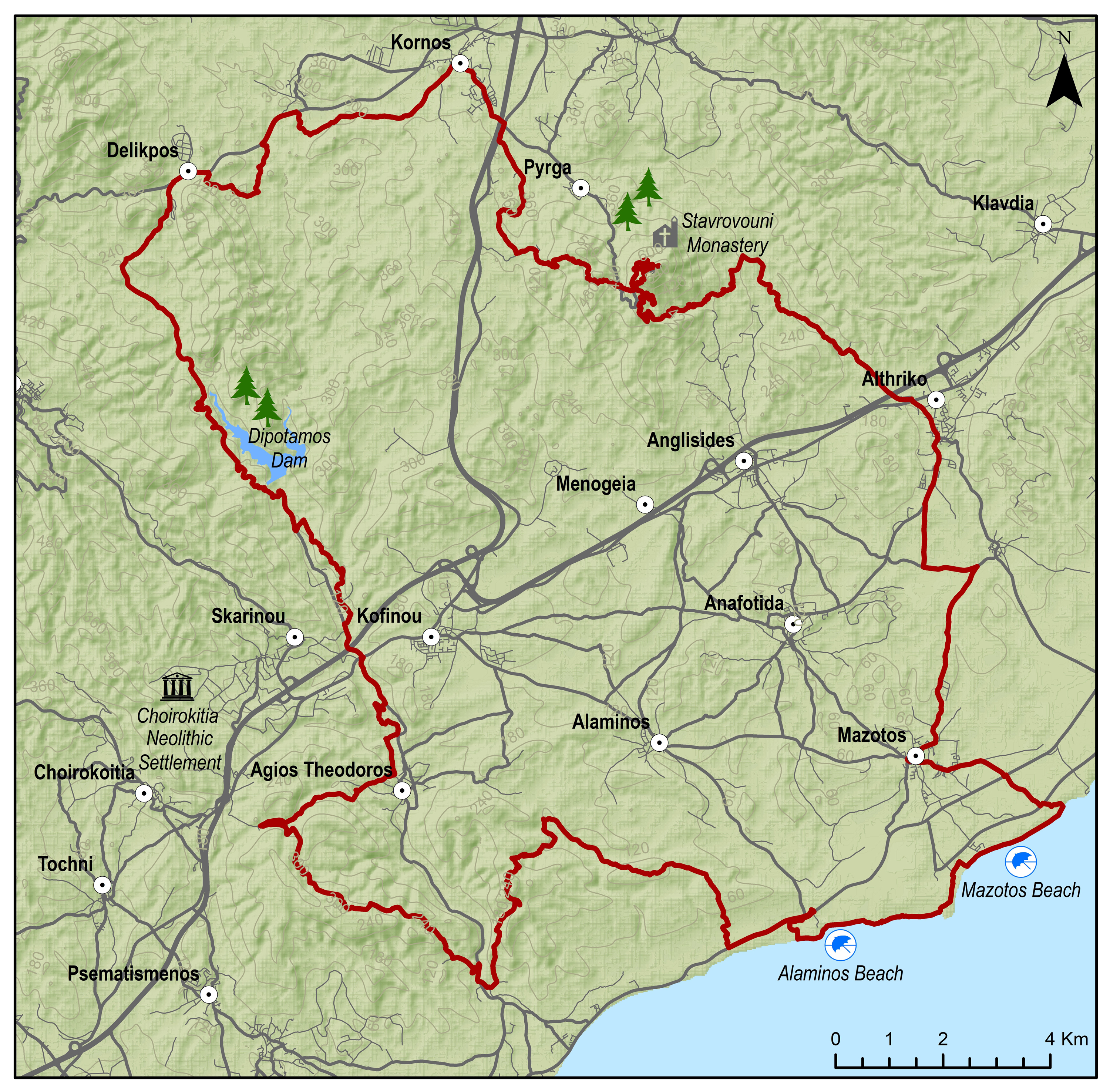
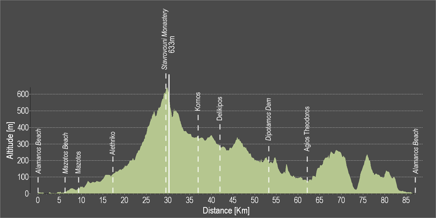
The route starts from the beach of Alaminos and continues along the coast to the villages of Mazotos and Alethriko, before going along the stunning uphill path that ends at the top of Stavrovouni, where the Holy Monastery of Stavrovouni is located, built on a rocky peak. The route then circles back downhill towards the village of Kornos, renowned for its traditional handmade clay vessels, as well as for its tradition in beekeeping, as it produces superior quality honey. Next, discover the village of Delikipos, the Dipotamos Reservoir and the beautiful and picturesque Agios Theodoros to finally reach the beach of Alaminos.
To download the route in gpx format click here
| Distance: | 87.0km |
| Elevation Gain: | 1638m |
| Highest point: | 633m |
| Lowest point: | 0m |
| Loop: | YES |
| Terrain: | Mountain |
| Section Distance (km) | Total Distance (km) | |
| Alaminos Beach | 0.0 | 0.0 |
| Mazotos Beach | 5.7 | 5.7 |
| Mazotos | 3.5 | 9.2 |
| Alethriko | 7.9 | 17.1 |
| Stvrovouni Monastery | 12.6 | 29.7 |
| Kornos | 8.1 | 37.8 |
| Delikipos | 5.0 | 42.8 |
| Dipotamos Dam | 12.3 | 55.1 |
| Agios Theodoros | 8.4 | 63.5 |
| Alaminos Beach | 23.5 | 87.0 |